AltiTrek — Offline Trail Navigation & 3D Spatial Telemetry
Engineered for mountaineering, endurance trail running, and cycling in remote backcountry environments without cellular infrastructure. AltiTrek fuses multi-constellation GNSS satellite positioning with on-device MEMS barometric pressure sensing for millibar-accurate elevation, vertical climb velocity, and autonomous squall forecasting. Connects to Bluetooth Low Energy (BLE) cardiac monitors, guides offline navigation with turn-by-turn routing, and reconstructs recorded sessions across interactive 3D spatial terrain models.

Reconstruct Expedition Routes in 3D Spatial Coordinate Space
Conduct granular post-session spatial analysis. Evaluate localized gradient variations, isolate critical climb crux milestones, and correlate velocity with biometric cardiac output across full 3D terrain models.
3D Vector & Satellite Topographic Terrain
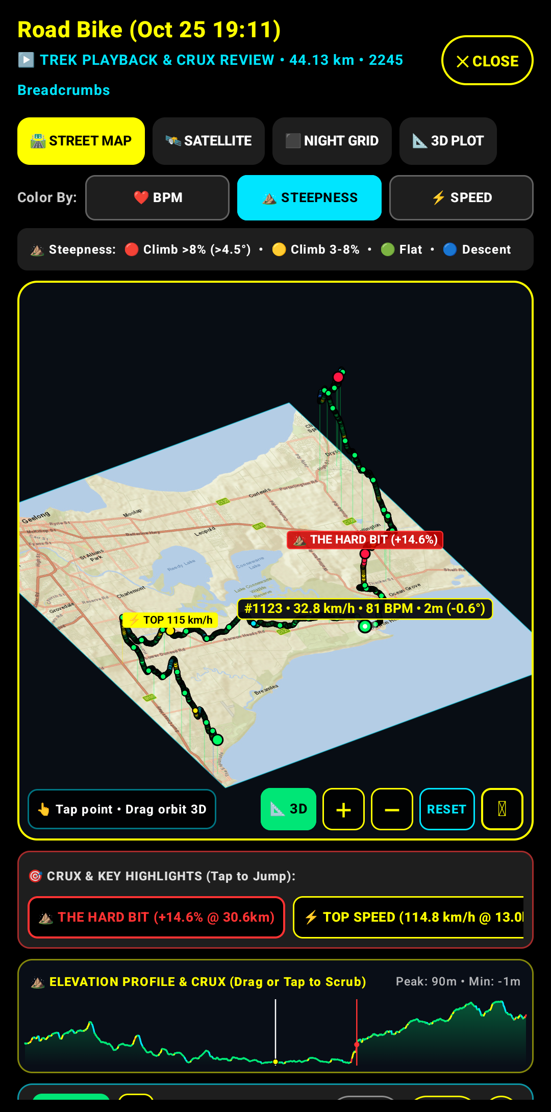
Extrudes GPS tracks into 3D spatial coordinate space with vertical elevation pillars color-coded by slope gradient steepness (>8%, 3–8%, flat, descent). Manipulate 3D camera orbit, pitch, and altitude to examine true topographic contours.
Automated Crux & Peak Exertion Detection
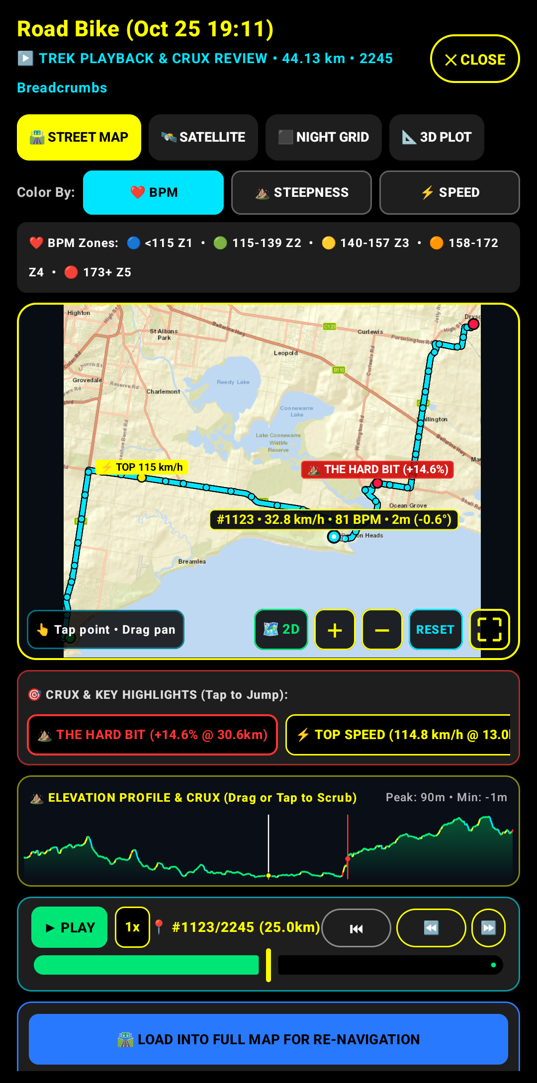
Telemetry algorithms automatically isolate the route's most demanding ascent grade (Crux), peak velocity, and summit milestone. Scrub along the timeline to inspect microsecond-synced speed, heart rate, elevation, and instantaneous slope angle.
Granular Telemetry Scrubbing
Inspect any coordinate along the route with precision scrubbing to review instantaneous velocity, heart rate (BPM), barometric elevation, and slope incline angle.
Autonomous Route Following & Staging
Ingest saved expeditions or third-party GPX tracks directly into the navigation engine for offline turn-by-turn guidance and voice split updates.
Adaptive Geospatial Viewport
Instantly toggle between a panoramic full-screen vector map and a synchronized multi-metric telemetry diagnostic dashboard.
Technical Architecture & Interface Tour
A systematic breakdown of AltiTrek's on-device sensor fusion, interactive mapping, and field telemetry screens.
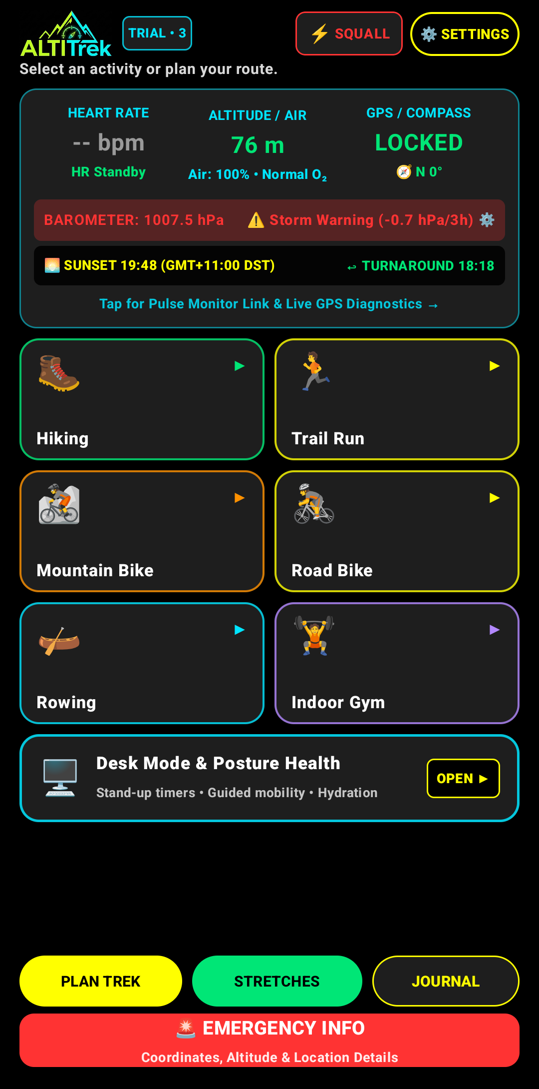
1. On-Device Mission Control Dashboard
Centralized operational dashboard synthesizing real-time barometric pressure (hPa), 3-hour squall tendency alerts, GNSS lock status, magnetic compass bearing, BLE cardiac telemetry, and automated solar ephemeris (sunset and turnaround countdown).
- ✓ Multi-sensor telemetry: Barometer (hPa), GPS/Compass Lock & BLE Heart Rate
- ✓ Predictive squall alerts & automated solar turnaround timeline calculation
- ✓ Direct launcher for 7 specialized activity profiles and emergency coordinates
2. 3D Geospatial Terrain & Crux Projection
Extrudes geographic coordinates into an interactive 3D spatial model. Color-coded topographic pillars illustrate slope incline categories while automated flag overlays highlight the climb Crux (+14.6%) and maximum velocity milestones.
- ✓ 3D spatial elevation extrusion with color-coded gradient slope classification
- ✓ Automated geographic flags for the climb Crux (+14.6%) and peak velocity
- ✓ Dual Street / Topo satellite layers with continuous orbit, pan, and tilt control
3. Biometric Heatmap & Telemetry Playback Engine
Synchronized multi-metric playback engine featuring 5-zone cardiovascular intensity mapping (Z1 Active Recovery through Z5 Peak Anaerobic). Enables variable-speed route replay, waypoint jump markers, and instant staging into active navigation.
- ✓ 5-zone biometric cardiac intensity heatmap (Z1–Z5) mapped directly to GPS route
- ✓ Interactive timeline scrubbing synchronized with ClimbPro elevation profile
- ✓ One-touch route staging into live vector map for autonomous field re-navigation
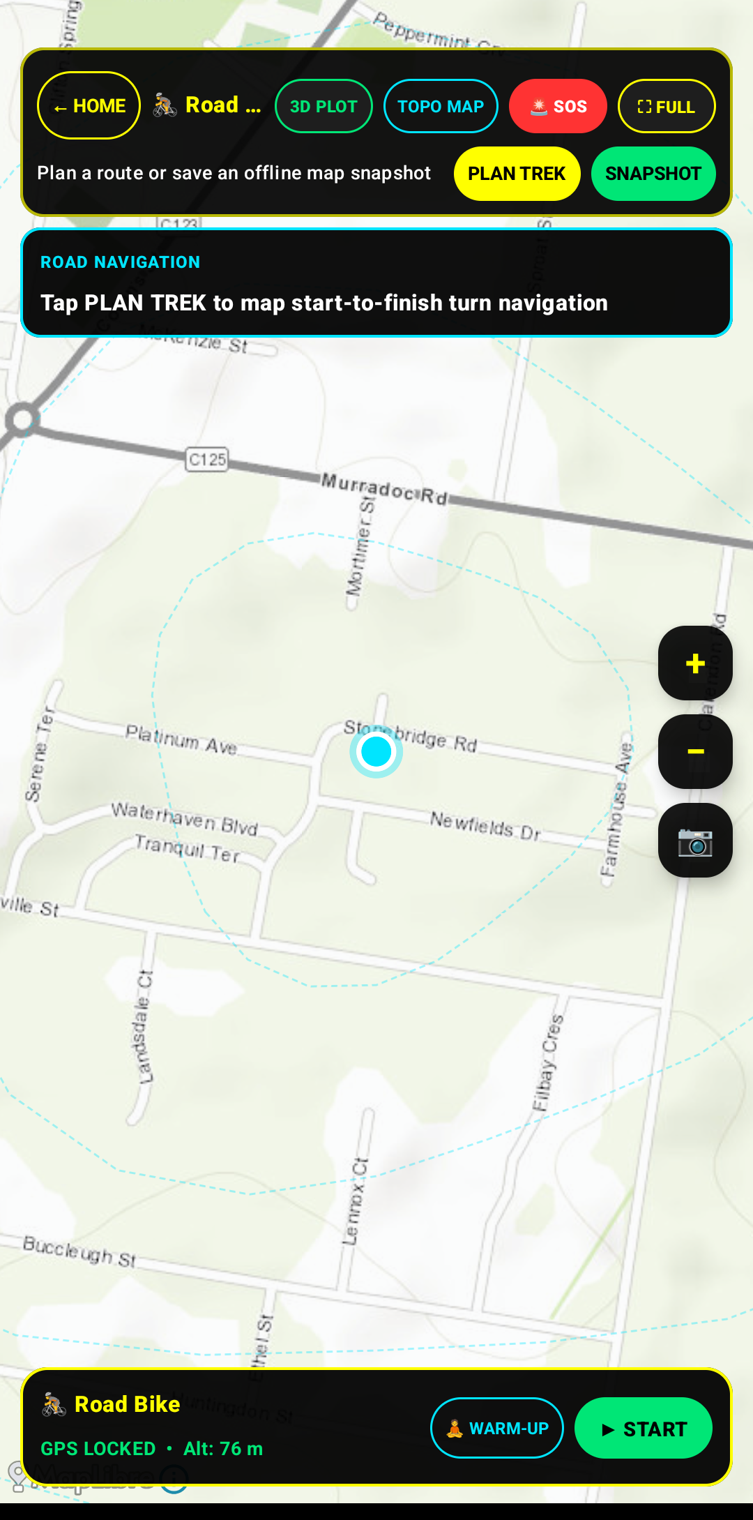
4. Tactical Map & Pre-Activity Route Planner
Tactical route preparation and vector map exploration interface. Features offline cached vector tiles, pre-departure route staging (PLAN TREK), terrain layer toggles (3D Plot, Topographic overlay), satellite lock status, and warm-up routine launcher.
- ✓ Offline vector road and trail mapping with custom viewport rotation
- ✓ Turn-by-turn route planner to pre-plot checkpoints and elevation profiles
- ✓ Pre-session diagnostics with GNSS lock status and warm-up protocol launcher
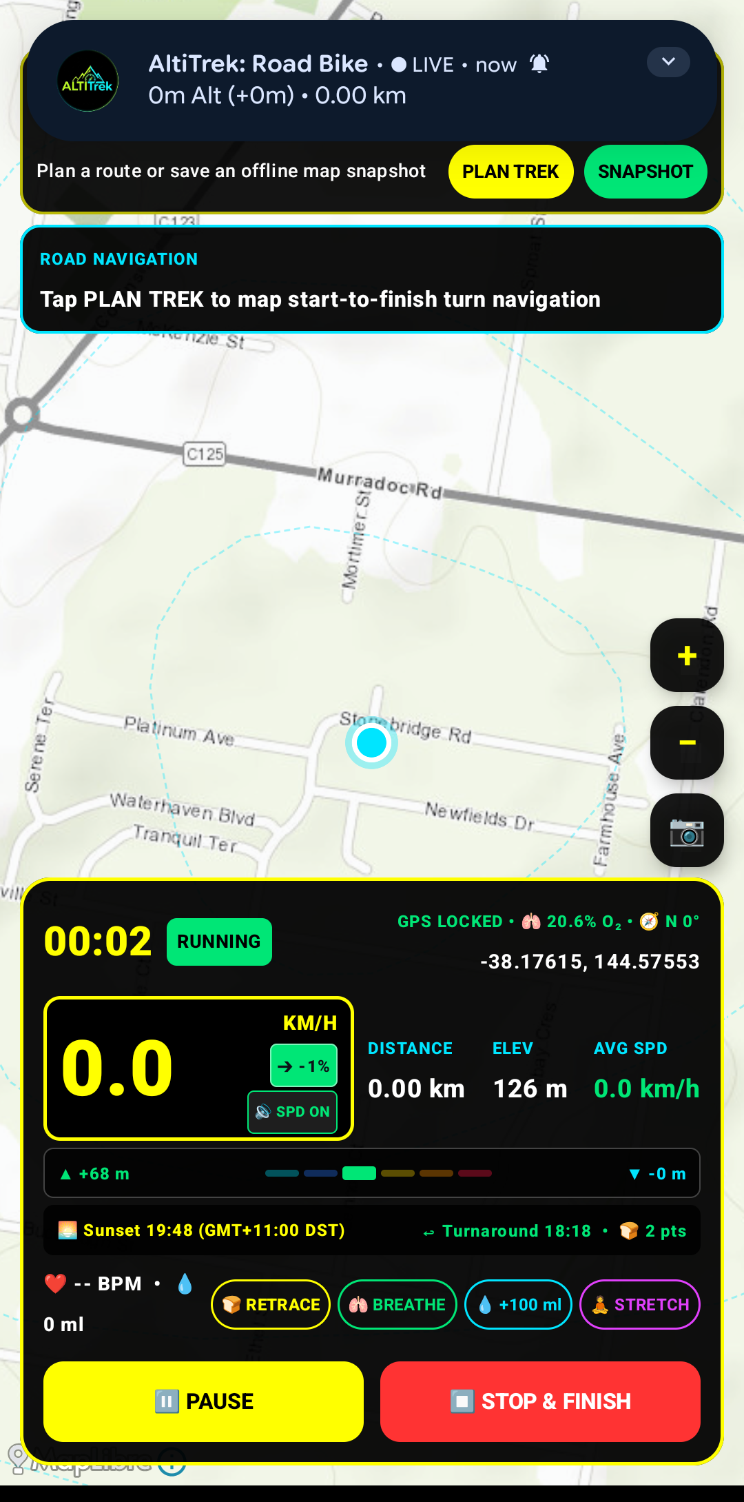
5. High-Visibility Cockpit Speedometer & Live HUD
Oversized, high-contrast dashboard engineered for handlebar and cockpit mounting in direct sunlight. Delivers instantaneous digital speed (km/h), live topographic slope incline grade (%), cumulative ascent/descent delta (▲ +68m / ▼ -0m), and solar sunset countdown.
- ✓ High-contrast digital speedometer with live gradient slope percentage
- ✓ Real-time barometric ascent/descent accumulation and distance tracking
- ✓ Quick-action buttons for breadcrumb retrace, hydration, and pacing
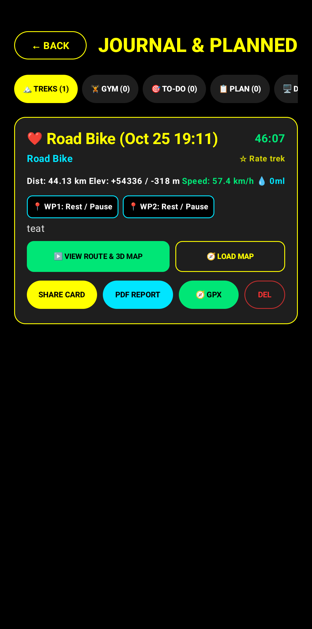
6. Telemetry Journal & Multi-Format Archive
Comprehensive local session journal with zero external cloud dependencies. Organizes completed expeditions, alpine ascents, trail runs, and cycling tours with comprehensive elevation, velocity, pacing, and multi-format export pipelines.
- ✓ Categorized on-device database for alpine treks, trail runs, and planned routes
- ✓ Detailed split metrics including waypoint markers and hydration totals
- ✓ Multi-format data pipeline: 3D Map replay, GPX, PDF report, and Share Card
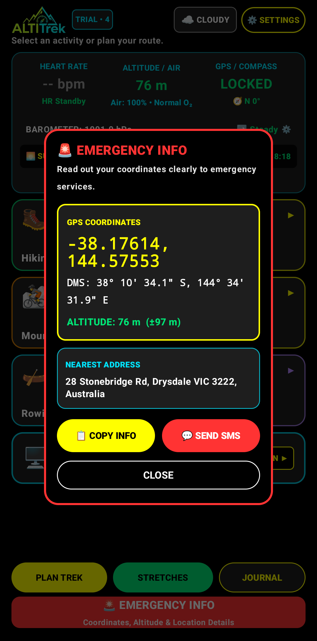
7. Emergency Geolocation & Coordinate Dispatch
High-precision emergency location module with a 2-second hold-to-activate physical/UI interlock preventing accidental triggers in rugged terrain. Instantly calculates decimal WGS84 coordinates, DMS notation, calibrated altitude, and reverse-geocoded address.
- ✓ 2-second hold interlock preventing false alarms during active movement
- ✓ Dual format coordinates: High-precision Decimal & Degree-Minutes-Seconds (DMS)
- ✓ One-tap clipboard export and direct SMS emergency dispatch integration
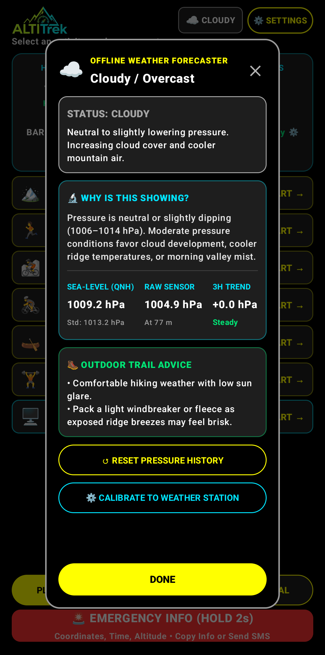
8. Autonomous Barometric Weather Forecaster & QNH Altimeter
On-device meteorological analysis engine utilizing the smartphone's integrated MEMS barometric pressure transducer. Continuously calculates 3-hour pressure tendencies (steady, falling, rising) to forecast weather transitions and detect sudden squalls without cellular connectivity.
- ✓ Continuous 3-hour barometric delta monitoring for squall & storm alerts
- ✓ Sea-level pressure (QNH) normalization vs. raw station pressure (hPa)
- ✓ Operates 100% autonomously in deep wilderness without cell coverage
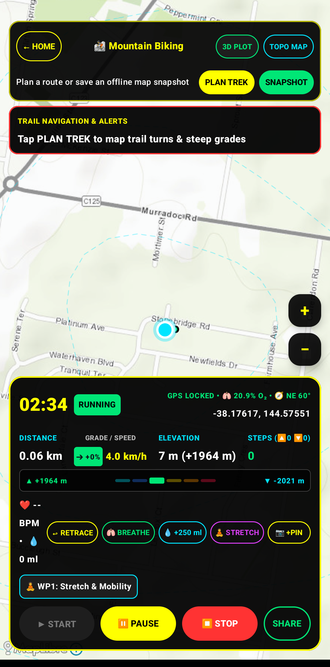
9. In-Field Active Session HUD & Waypoint Marking
Real-time active tracking and in-field waypoint management console for mountain biking and alpine navigation. Integrates live vector trail mapping with continuous GNSS coordinates, real-time grade slope (% incline), barometric vertical delta (▲ +1964m / ▼ -2021m), tactical back-azimuth retrace, and on-the-fly hydration logging.
- ✓ Live topographic trail tracking with instantaneous grade % & velocity
- ✓ On-the-fly tactical waypoint creation (+PIN, WP1: Stretch & Mobility)
- ✓ One-tap hydration logging, guided breathing pacing, and backtrack retrace
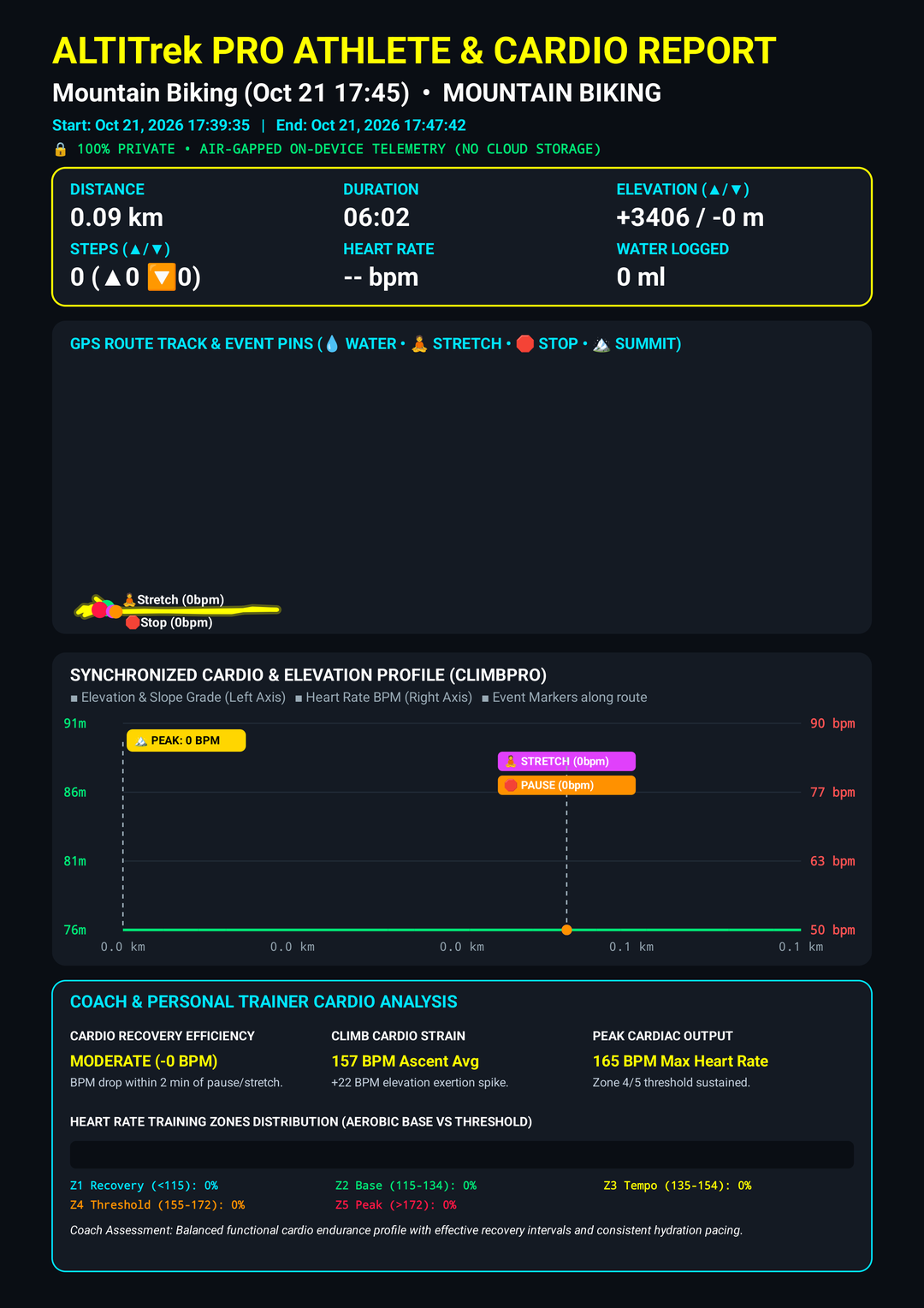
10. Comprehensive Activity & Biometric Telemetry Report
Vector-rendered multi-page expedition and athletic performance report generated 100% on-device. Compiles synchronized ClimbPro cardio-elevation profiles, dual-axis slope and heart rate correlation, biometric training zone distributions (Z1 Recovery to Z5 Peak), cardio recovery efficiency, and climb exertion strain analysis.
- ✓ Vector-rendered 2-page activity report generated 100% locally on-device
- ✓ Synchronized ClimbPro elevation & cardiovascular dual-axis charts
- ✓ Personal trainer & athletic recovery metrics with heart rate zone breakdown
Engineered for Multi-Discipline Expedition Tracking
Dedicated tracking engines with customized sensor sample rates, telemetry filters, and specialized cockpit layouts.
Alpine Trekking & Hiking
High-accuracy GNSS navigation, barometric elevation gain/loss profiling, waypoint landmark logging, and automated backtrack guidance.
Mountain & Trail Running
Real-time pace metrics, split timing, vertical ascent rate tracking, and cadence analysis across rugged topographic terrain.
Enduro & Mountain Biking
High-vis cockpit HUD, 3D slope gradient analysis, distance to trail end, and instant turn-by-turn re-navigation.
Road Cycling & Criterium
High-contrast speedometer, continuous average speed tracking, climb grade percentage, and standard GPX export.
Aquatic Rowing & Paddling
Water-track GPS heading, split pace per 500 meters, cumulative distance, and return-to-launch compass bearing.
Alpine Expeditions & Team Convoys
Real-time multi-device fleet telemetry, convoy beacon tracking, distress emergency sirens, and live group radar for remote backcountry team expeditions.
Autonomous Architecture & Field-Ready Capabilities
Robust on-device telemetry algorithms engineered without third-party cloud dependencies.
Zero-Cloud Autonomous Operation
Interfaces directly with GNSS satellite constellations. Offline vector map tiles and elevation models remain permanently cached on-device for uninterrupted operation in remote wilderness.
Precision Barometric Altimetry & Squall Detection
Harnesses the smartphone's internal MEMS barometric pressure sensor. Delivers sub-meter vertical ascent responsiveness and autonomously alerts users to sudden meteorological pressure drops.
BLE Biometric Telemetry & Cardiac Zones
Pairs with standard Bluetooth Low Energy (BLE) chest straps and smartwatches. Displays real-time heart rate (BPM) mapped across 5 standardized cardiovascular intensity zones.
Curated Trail Database & Session Archive
Store target expeditions with distance objectives. Completed routes archive automatically with quantitative split metrics, user notes, and 1–5 star difficulty ratings.
Standardized Multi-Format Telemetry Export
Exports standard GPX tracks with full geographic, barometric, and cardiac telemetry points, vector-rendered 2-page PDF activity reports, and high-resolution route cards.
Tactical Geolocation & Emergency Dispatch
Integrated 2-second hold-to-activate emergency protocol displaying high-precision WGS84 decimal and DMS coordinates, barometric altitude, and rapid SMS emergency dispatch.
Uncompromising On-Device Data Privacy
AltiTrek operates entirely on-device without remote user accounts, advertising trackers, or external cloud telemetry synchronization. All GPS tracks, biometric recordings, waypoints, and photos are retained exclusively within your device's encrypted local storage.
Read the AltiTrek Privacy Architecture →